Celebrating 25 years of DDD's Excellence and Social Impact. ✖

Computer Vision

multimodal2Bannotation

Multi-Modal Data Annotation for Autonomous Perception: Synchronizing LiDAR, RADAR, and Camera Inputs

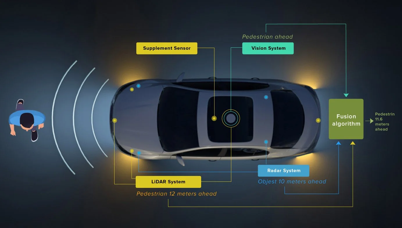
Autonomy relies on their ability to perceive and interpret the world around them accurately and resiliently. To achieve this, modern perception stacks increasingly depend on data from multiple sensor modalities, particularly LiDAR, RADAR, and cameras. Each of these sensors brings unique strengths: LiDAR offers precise 3D spatial data, RADAR excels in detecting objects under poor lighting or adverse weather, and cameras provide rich visual detail and semantic context. However, the true potential of these sensors is unlocked when their inputs are combined effectively through synchronized, high-quality data annotation.

Multi-modal annotation requires more than simply labeling data from different sensors. It requires precise spatial and temporal alignment, calibration across coordinate systems, handling discrepancies in resolution and frequency, and developing workflows that can consistently handle large-scale data. The problem becomes even more difficult in dynamic environments, where occlusions, motion blur, or environmental noise can lead to inconsistencies across sensor readings.

This blog explores multi-modal data annotation for autonomy, focusing on the synchronization of LiDAR, RADAR, and camera inputs. It provides a deep dive into the challenges of aligning sensor streams, the latest strategies for achieving temporal and spatial calibration, and the practical techniques for fusing and labeling data at scale. It also highlights real-world applications, fusion frameworks, and annotation best practices that are shaping the future of autonomous systems across industries such as automotive, robotics, aerial mapping, and surveillance.

Why Multi-Modal Sensor Fusion is Important

Modern autonomous systems operate in diverse and often unpredictable environments, from urban streets with heavy traffic to warehouses with dynamic obstacles and limited lighting. Relying on a single type of sensor is rarely sufficient to capture all the necessary environmental cues. Each sensor type has inherent limitations; cameras struggle in low-light conditions, LiDAR can be affected by fog or rain, and RADAR, while robust in weather, lacks fine-grained spatial detail. Sensor fusion addresses these gaps by combining the complementary strengths of multiple modalities, enabling more reliable and context-aware perception.

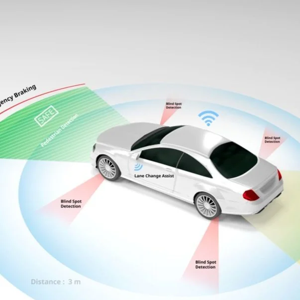
LiDAR provides dense 3D point clouds that are highly accurate for mapping and localization, particularly useful in estimating depth and object geometry. RADAR contributes reliable measurements of velocity and range, performing well in adverse weather where other sensors may fail. Cameras add rich semantic understanding of the scene, capturing textures, colors, and object classes that are critical for tasks like traffic sign recognition and lane detection. By fusing data from these sensors, systems can form a more comprehensive and redundant view of the environment.

This fusion is particularly valuable for safety-critical applications. In autonomous vehicles, for example, sensor redundancy is essential for detecting edge cases, unusual or rare situations where a single sensor may misinterpret the scene. A RADAR might detect a metal object hidden in shadow, which a camera might miss due to poor lighting. A LiDAR might capture the exact 3D contour of an object that RADAR detects only as a motion vector. Combining these views improves object classification accuracy, reduces false positives, and allows for better predictive modeling of moving objects.

Beyond transportation, sensor fusion also plays a key role in domains such as robotics, smart infrastructure, aerial mapping, and defense. Indoor robots navigating warehouse floors benefit from synchronized RADAR and LiDAR inputs to avoid collisions. Drones flying in mixed lighting conditions can rely on RADAR for obstacle detection while using cameras for visual mapping. Surveillance systems can use fusion to detect and classify objects accurately, even in rain or darkness.

This makes synchronized data annotation not just a technical necessity but a foundational requirement. Poorly aligned or inconsistently labeled data can degrade model performance, create safety risks, and increase the cost of re-training. In the next section, we examine why this annotation process is so challenging and what makes it a key bottleneck in building robust, sensor-fused systems.

Challenges in Multi-Sensor Data Annotation

Creating reliable multi-modal datasets requires more than just capturing data from LiDAR, RADAR, and cameras. The true challenge lies in synchronizing and annotating this data in a way that maintains spatial and temporal coherence across modalities. These challenges span hardware limitations, data representation discrepancies, calibration inaccuracies, and practical workflow constraints that scale with data volume.

Temporal Misalignment: Different sensors operate at different frequencies and latencies. LiDAR may capture data at 10 Hz, RADAR at 20 Hz, and cameras at 30 or even 60 Hz. Synchronizing these streams in time, especially in dynamic environments with moving objects, is critical. A delay of even a few milliseconds can result in misaligned annotations, leading to errors in training data that compound over time in model performance.

Spatial Calibration: Each sensor occupies a different physical position on the vehicle or robot, with its own frame of reference. Accurately transforming data between coordinate systems, camera images, LiDAR point clouds, and RADAR reflections requires meticulous intrinsic and extrinsic calibration. Even small calibration errors can cause significant inconsistencies, such as bounding boxes that appear correctly in one modality but are misaligned in another. These discrepancies undermine the integrity of fused annotations and reduce the effectiveness of perception models trained on them.

Heterogeneity of Sensor Data: Cameras output 2D image grids with RGB values, LiDAR provides sparse or dense 3D point clouds, and RADAR offers a different type of 3D or 4D data that is often noisier and lower in resolution but includes velocity information. Designing annotation pipelines that can handle this variety of data formats and fuse them meaningfully is non-trivial. Moreover, each modality perceives the environment differently: transparent or reflective surfaces may be captured by cameras but not by LiDAR, and small or non-metallic objects may be missed by RADAR altogether.

Scale of Annotation: Autonomous systems collect vast amounts of data across thousands of hours of driving or operation. Annotating this data manually is prohibitively expensive and time-consuming, especially when high-resolution 3D data is involved. Creating accurate annotations across all modalities requires specialized tools and domain expertise, often involving a combination of human effort, automation, and validation loops.

Quality Control and Consistency: Annotators must maintain uniform labeling across modalities and frames, which is challenging when occlusions or environmental conditions degrade visibility. For example, an object visible in RADAR and LiDAR might be partially occluded in the camera view, leading to inconsistent labels if the annotator is not equipped with a fused perspective. Without robust QA workflows and annotation standards, dataset noise can slip into training pipelines, affecting model reliability in edge cases.

Data Annotation and Fusion Techniques for Multi-modal Data

Effective multi-modal data annotation is inseparable from how well sensor inputs are fused. Synchronization is not just about matching timestamps; it’s about aligning data with different sampling rates, coordinate systems, noise profiles, and detection characteristics. Over the past few years, several techniques and frameworks have emerged to handle the complexity of fusing LiDAR, RADAR, and camera inputs at both the data and model levels.

Time Synchronization: Hardware-based synchronization using shared clocks or protocols like PTP (Precision Time Protocol) is ideal, especially for systems where sensors are integrated into a single rig. In cases where that’s not feasible, software-based alignment using timestamp interpolation can be used, often supported by GPS/IMU signals for temporal correction. Some recent datasets, like OmniHD-Scenes and NTU4DRadLM, include such synchronization mechanisms by default, making them a strong foundation for fusion-ready annotations.

Spatial Alignment: Requires precise intrinsic calibration (lens distortion, focal length, etc.) and extrinsic calibration (relative position and orientation between sensors). Calibration targets like checkerboards, AprilTags, and reflective markers are widely used in traditional workflows. However, newer approaches like SLAM-based self-calibration or indoor positioning systems (IPS) are gaining traction. The IPS-based method published in IRC 2023 demonstrated how positional data can be used to automate the projection of 3D points onto camera planes, dramatically reducing manual intervention while maintaining accuracy.

Once synchronization is achieved, fusion strategies come into play. These are generally classified into three levels: early fusion, mid-level fusion, and late fusion. In early fusion, data from different sensors is combined at the raw or pre-processed input level.

For example, projecting LiDAR point clouds onto image planes allows joint annotation in a common 2D space, though this requires precise calibration. Mid-level fusion works on feature representations. Here, feature maps generated separately from each sensor are aligned, and the merged approach supports flexibility while preserving modality-specific strengths. Late fusion, on the other hand, happens after detection or segmentation, where predictions from each modality are combined to arrive at a consensus result. This modular design is seen in systems like DeepFusion, which allows independent tuning and failure isolation across modalities.

Annotation pipelines increasingly integrate fusion-aware workflows, enabling annotators to see synchronized sensor views side by side or as overlaid projections. This ensures label consistency and accelerates quality control, especially in ambiguous or partially occluded scenes. As the ecosystem matures, we can expect to see more fusion-aware annotation tools, dataset formats, and APIs designed to make multi-modal perception easier to build and scale.

Real-World Applications of Multi-Modal Data Annotation

As multi-modal sensor fusion matures, its applications are expanding across industries where safety, accuracy, and environmental adaptability are non-negotiable.

In the autonomous vehicle sector, multi-sensor annotation enables precise 3D object detection, lane-level semantic segmentation, and robust behavior prediction. Leading datasets have demonstrated the importance of combining LiDAR’s spatial resolution with camera-based semantics and RADAR’s motion sensitivity. Cooperative perception is becoming especially prominent in connected vehicle ecosystems, where synchronized data from multiple vehicles or roadside units allows for enhanced situational awareness.

In such scenarios, accurate multi-modal annotation is crucial to training models that can understand not just what is visible from one vehicle’s perspective, but from the entire connected network’s viewpoint.

Indoor Robotics: Multi-modal fusion is also central to, especially in warehouse automation, where autonomous forklifts and inspection robots must navigate tight spaces filled with shelves, reflective surfaces, and moving personnel. These environments often lack consistent lighting, making RADAR and LiDAR essential complements to vision systems. Annotated sensor data is used to train SLAM (Simultaneous Localization and Mapping) and obstacle avoidance algorithms that operate in real time.

Aerial Systems: Drones used for inspection, surveying, and delivery, combining camera feeds with LiDAR and RADAR inputs, significantly improve obstacle detection and terrain mapping. These systems frequently operate in GPS-denied or visually ambiguous settings, like fog, dust, or low-light, where single-sensor reliance leads to failure. Multi-modal annotations help train detection models that can anticipate and adapt to such environmental challenges.

Surveillance and Smart Infrastructure Platforms: In environments like airports, industrial zones, or national borders, it’s not enough to simply detect objects; systems must identify, classify, and track them reliably under a wide range of conditions. Fused sensor systems using RADAR for motion detection, LiDAR for shape estimation, and cameras for classification are proving to be more resilient than vision-only systems. Accurate annotation across modalities is essential here to build datasets that reflect the diversity and unpredictability of these high-security environments.

Read more: Accelerating HD Mapping for Autonomy: Key Techniques & Human-In-The-Loop

Best Practices for Multi-Modal Data Annotation

Building high-quality, multi-modal datasets that effectively synchronize LiDAR, RADAR, and camera inputs requires a deliberate approach. From data collection to annotation, every stage must be designed with fusion and consistency in mind. Over the past few years, organizations working at the forefront of autonomous systems have refined a number of best practices that significantly improve the efficiency and quality of multi-sensor annotation pipelines.

Investing in sensor synchronization infrastructure 

Systems that use hardware-level synchronization, such as shared clocks or PPS (pulse-per-second) signals from GPS units, dramatically reduce the need for post-processing alignment. If such hardware is unavailable, software-level timestamp interpolation should be guided by auxiliary sensors like IMUs or positional data to minimize drift and latency mismatches. Pre-synchronized datasets demonstrate how much easier annotation becomes when synchronization is already built into the data.

Prioritize accurate and regularly validated calibration procedures

Calibration is not a one-time setup; it must be repeated frequently, especially in mobile platforms where physical alignment between sensors can degrade over time due to vibrations or impacts. Using calibration targets is still standard, but emerging methods that leverage SLAM or IPS-based calibration are proving to be faster and more robust. These automated methods not only save time but also reduce dependency on highly trained personnel for every calibration event.

Embrace fusion-aware tools that present data 

Annotators should be able to view 2D and 3D representations side by side or in overlaid projections to ensure label consistency. When possible, annotations should be generated in a unified coordinate system rather than labeling each modality separately. This helps eliminate ambiguity and speeds up validation.

Integrate a semi-automated labeling approach

These include model-assisted pre-labeling, SLAM-based object tracking for temporal consistency, and projection tools that allow 3D labels to be viewed or edited in camera space. Automation doesn’t replace manual review, but it reduces the cost per frame and makes large-scale dataset creation more feasible. Combining this with human-in-the-loop QA processes ensures that quality remains high while annotation throughput improves.

Cross-modality QA mechanisms

Errors that occur in one sensor view often cascade into others, so quality control should include consistency checks across modalities. These can be implemented through projection-based overlays, intersection-over-union (IoU) comparisons of bounding boxes across views, or automated checks for calibration drift. Without these controls, even well-labeled datasets can contain silent failures that compromise model performance.

Read more: Utilizing Multi-sensor Data Annotation To Improve Autonomous Driving Efficiency

Conclusion

As the demand for high-performance autonomous systems grows, the importance of synchronized, multi-modal data annotation becomes increasingly clear. The fusion of LiDAR, RADAR, and camera data allows perception models to interpret their environments with greater depth, resilience, and semantic understanding than any single modality can offer. However, realizing the benefits of this fusion requires meticulous attention to synchronization, calibration, data consistency, and annotation workflow design.

The future of perception will be defined not just by model architecture or training techniques, but by the quality and integrity of the data these systems learn from. For teams working in autonomous driving, humanoids, surveillance, or aerial mapping, multi-modal data annotation is no longer an experimental technique; it’s a necessity. As tools and standards mature, those who invest early in fusion-ready datasets and workflows will be better positioned to build systems that perform reliably, even in the most challenging real-world scenarios.

Leverage DDD’s deep domain experience, fusion-aware annotation pipelines, and cutting-edge toolsets to accelerate your AI development lifecycle. From dataset design to sensor calibration support and semi-automated labeling, we partner with you to ensure your models are trained on reliable, production-grade data.

Ready to transform your perception stack with sensor-fused training data? Get in touch


References:

Baumann, N., Baumgartner, M., Ghignone, E., Kühne, J., Fischer, T., Yang, Y.‑H., Pollefeys, M., & Magno, M. (2024). CR3DT: Camera‑RADAR fusion for 3D detection and tracking. arXiv preprint. https://doi.org/10.48550/arXiv.2403.15313

Rubel, R., Dudash, A., Goli, M., O’Hara, J., & Wunderlich, K. (2023, December 6). Automated multimodal data annotation via calibration with indoor positioning system. arXiv. https://doi.org/10.48550/arXiv.2312.03608

Frequently Asked Questions (FAQs)

1. Can synthetic data be used for multi-modal training and annotation?
Yes, synthetic datasets are becoming increasingly useful for pre-training models, especially for rare edge cases. Simulators can generate annotated LiDAR, RADAR, and camera data.

2. How is privacy handled in multi-sensor data collection, especially in public environments?
Cameras can capture identifiable information, unlike LiDAR or RADAR. To address privacy concerns, collected image data is often anonymized through blurring of faces and license plates before annotation or release. Additionally, data collection in public areas may require permits and explicit privacy policies, particularly in the EU under GDPR regulations.

3. Is it possible to label RADAR data directly, or must it be fused first?
RADAR data can be labeled directly, especially when used in its image-like formats (e.g., range-Doppler maps). However, due to its sparse and noisy nature, annotations are often guided by fusion with LiDAR or camera data to increase interpretability. Some tools now allow direct annotation in radar frames, but it’s still less mature than LiDAR/camera workflows.

4. How do annotation errors in one modality affect model performance in fusion systems?
An error in one modality can propagate and confuse feature alignment or consensus mechanisms, especially in mid- and late-fusion architectures. For example, a misaligned bounding box in LiDAR space can degrade the effectiveness of a BEV fusion layer, even if the camera annotation is correct.

Multi-Modal Data Annotation for Autonomous Perception: Synchronizing LiDAR, RADAR, and Camera Inputs Read Post »

syntheticdataforcomputervision

Synthetic Data for Computer Vision Training: How and When to Use It

Training high-performance computer vision models requires vast amounts of labeled image and video data. From object detection in autonomous vehicles to facial recognition in security systems, the success of modern AI systems hinges on the quality and diversity of the data they learn from.

Gathering real-world datasets is costly, time-intensive, and often fraught with legal, ethical, and logistical barriers. Data annotation alone can consume significant resources, and ensuring representative coverage of all necessary edge cases is an even steeper challenge.

These limitations have sparked growing interest in synthetic data, artificially generated data designed to replicate the statistical properties of real-world visuals. Advances in simulation engines, procedural generation, and generative AI models have made it possible to produce photorealistic scenes with controlled variables, enabling fine-grained customization of training scenarios.

In this blog, we will explore synthetic data for computer vision, including its creation, application, and the strengths and limitations it presents. We will also examine how synthetic data is transforming the landscape of computer vision training using real-world use cases.

What Is Synthetic Data in Computer Vision?

Synthetic data refers to artificially generated data that is designed to closely resemble real-world imagery. In the context of computer vision, this includes images, videos, and annotations that replicate the visual characteristics of actual environments, objects, and scenarios. Rather than capturing data from physical sensors like cameras, synthetic data is produced through computational means, ranging from 3D simulation engines to advanced generative models.

Synthetic data is not just a placeholder or proxy for real data; when designed effectively, it can enrich and even outperform real datasets in specific training contexts, especially where real-world data is scarce, biased, or ethically sensitive.

Types of Synthetic Data

Fully Synthetic Images (3D Rendered):
These are generated using simulation platforms like Unreal Engine or Unity. Developers model environments, objects, lighting, and camera positions to produce photo-realistic images complete with metadata such as depth maps, segmentation masks, and bounding boxes. These scenes are often used in autonomous driving, robotics, and industrial inspection.

GAN-Generated Images (Deep Generative Models):
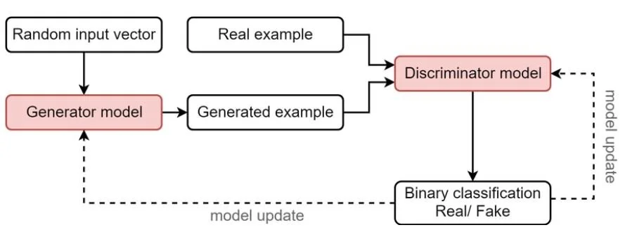
Generative Adversarial Networks (GANs) and Variational Autoencoders (VAEs) can produce synthetic images that are indistinguishable from real ones. These models learn patterns from real datasets and then generate new, high-fidelity samples. This approach is particularly useful for style transfer, face generation, and domain adaptation tasks.

Augmented Real Images:
In this hybrid method, real images are augmented with synthetic elements, like overlaying virtual objects, applying stylized transformations, or compositing backgrounds. Neural style transfer, texture mapping, and data augmentation techniques fall under this category. These methods help bridge the domain gap between synthetic and real-world data.

Common Use Cases of Synthetic Data in Computer Vision

Object Detection and Classification:
Synthetic data helps create large, diverse datasets for detecting specific items under varied lighting, angles, and occlusion conditions. This is widely used in warehouse automation and retail shelf analysis.

Facial Recognition:
Privacy concerns and demographic imbalance in facial datasets have made synthetic human face generation a critical area of innovation. Synthetic faces enable model training without using personally identifiable information (PII).

Rare Event Detection:
For safety-critical applications like autonomous driving or aerial surveillance, collecting real-world footage of rare scenarios (e.g., car crashes, pedestrians in unexpected areas, or extreme weather) is nearly impossible. Synthetic simulations allow safe and repeatable reproduction of such edge cases.

Why Use Synthetic Data for Training Computer Vision Models?

Synthetic data offers a compelling array of advantages that address the limitations of real-world data collection, especially in computer vision. From economic and logistical gains to ethical and technical benefits, it has become a strategic asset in the AI model development pipeline.

Cost-Efficiency

Collecting and labeling real-world data is notoriously expensive. In domains like autonomous driving or industrial inspection, acquiring edge-case imagery can cost millions of dollars and months of manual annotation. Synthetic data, on the other hand, can be generated at scale with automated labeling included, drastically reducing both time and budget.

Speed

Traditional dataset development may take weeks or months, especially when capturing niche scenarios. Synthetic data platforms can generate thousands of labeled examples in hours. This rapid turnaround accelerates experimentation and iteration, which is crucial for fast-moving development cycles and proof-of-concept phases.

Bias Control

Real-world datasets often suffer from demographic, geographic, or environmental bias, leading to skewed model behavior. With synthetic data, practitioners can generate balanced datasets, ensuring uniform coverage across object classes, lighting conditions, weather scenarios, and more. This allows models to generalize better across diverse real-world situations.

Privacy & Security

In fields like medical imaging or facial recognition, privacy regulations (e.g., GDPR, HIPAA) limit access to personal data. Synthetic datasets eliminate this concern, as they are artificially generated and contain no personally identifiable information (PII). This enables safe data sharing and cross-border collaboration without legal hurdles.

Rare Scenarios

Capturing rare but critical scenarios, such as a child running into the street or a factory machine catching fire, is practically impossible and ethically problematic in real life. Synthetic environments can simulate these edge cases repeatedly and safely, allowing models to be trained on events they might otherwise never encounter until deployment.

When Should You Use Synthetic Data for Computer Vision?

Synthetic data isn’t a universal solution for every computer vision challenge, but it becomes incredibly powerful in specific scenarios. Understanding when to integrate synthetic data into your machine learning pipeline can make the difference between a high-performing model and one plagued by gaps or biases.

Best Scenarios for Synthetic Data Use

Data Scarcity or Imbalance

When real-world data is limited, synthetic data can fill the void. For example, rare medical conditions or uncommon vehicle configurations may not appear often in traditional datasets. With synthetic generation, you can control the class balance, ensuring underrepresented categories are well-represented.

Safety-Critical Training

In applications like healthcare robotics or autonomous vehicles, safety is paramount. Training AI systems to respond to dangerous or emergency scenarios requires data that is often too risky or unethical to collect in real life. Synthetic simulations enable you to model these situations precisely, without putting people or equipment at risk.

Rare Scenario Modeling

Whether it’s a pedestrian jaywalking at night or a drone navigating through fog, rare edge cases can be crucial for model performance. Synthetic data makes it easy to generate and iterate on these low-frequency, high-impact events.

Rapid Prototyping

Early-stage development or exploratory model experimentation often suffers from a lack of real data. Using synthetic datasets lets teams quickly test hypotheses and refine algorithms, speeding up the proof-of-concept stage.

Limitations & Red Flags

Despite its advantages, synthetic data comes with limitations that must be acknowledged to use it effectively.

Domain Gap / Realism Challenges

Synthetic data often lacks the nuance and imperfection of real-world environments. Factors like lighting, noise, sensor distortions, and unexpected object interactions can be difficult to simulate accurately. This leads to a “domain gap” that, if not bridged, can cause models trained on synthetic data to underperform on real-world inputs.

Overfitting to Synthetic Artifacts

Models can become overly reliant on synthetic-specific patterns, like overly clean segmentation boundaries or overly uniform object shapes. Without mixing real-world examples, there’s a risk of training on visual cues that don’t exist in deployment environments.

Diminishing Returns with Large-Scale Real Data

For companies that already possess massive, diverse real-world datasets, the incremental value of synthetic data may be limited, unless used for domain-specific augmentation or rare case simulations.

How Is Synthetic Data Generated?

Generating high-quality synthetic data for computer vision involves a combination of simulation technologies, generative AI models, and image transformation techniques. Each method varies in complexity, realism, and use case suitability. Here’s a breakdown of the most common approaches and the leading platforms that make them accessible.

Methods of Synthetic Data Generation

3D Rendering Engines

Tools like Unity and Unreal Engine 4 allow developers to build detailed virtual environments, populate them with objects, simulate lighting, physics, and camera angles, and output annotated images. This method offers complete control over every aspect of the data, perfect for industrial inspection, robotics, and autonomous vehicle training.

Example: A warehouse simulation can create thousands of images of pallets, forklifts, and workers from different angles and lighting conditions, complete with segmentation masks and bounding boxes.

GANs and VAEs (Generative Models)

Generative Adversarial Networks (GANs) and Variational Autoencoders (VAEs) are used to create synthetic images that statistically resemble real data. Trained on real-world samples, these models can generate new variations that look realistic, often indistinguishable to the human eye.

Use Case: Generating synthetic human faces, fashion products, or medical anomalies for augmenting limited datasets.

Rule-Based Scripting

In procedural generation, structured rules are used to create variations in layout, positioning, object size, and color combinations. This is often used in simpler environments where high realism isn’t critical but structural diversity is needed, such as document layouts, barcodes, or street signs.

Neural Style Transfer / Image Augmentation

These techniques manipulate existing real images by altering textures, backgrounds, or stylistic elements to simulate domain shifts. They’re useful for domain adaptation tasks, e.g., turning daytime images into nighttime scenes or applying cartoon filters for synthetic simulation.

Real-World Applications of Synthetic Data in Computer Vision

Synthetic data is already transforming computer vision systems across industries, especially where data scarcity, privacy, or risk is a concern. These use cases demonstrate how organizations are using synthetic data not just as a stopgap, but as a cornerstone of their AI strategies.

Healthcare

Use Case: Simulating Pathologies for Medical Imaging

In radiology and diagnostics, collecting large volumes of labeled imaging data is time-consuming, expensive, and constrained by patient privacy laws like HIPAA and GDPR. Synthetic data allows developers to generate CT scans, X-rays, and MRIs with simulated abnormalities (e.g., tumors, fractures, rare diseases), enabling robust training of diagnostic AI systems

Read more: The Emerging Role of Computer Vision in Healthcare Diagnostics

Autonomous Vehicles

Use Case: Generating Edge Cases in Driving Scenarios

Self-driving car systems must be prepared for thousands of unpredictable situations, icy roads, jaywalking pedestrians, and unusual vehicle behavior. Capturing such events in real life is often unfeasible or unsafe. Simulation environments can generate thousands of such edge-case scenarios, complete with accurate physics and sensor metadata.

Retail and E-Commerce

Use Case: Virtual Products for Shelf Detection and Inventory Management

Retailers and E-commerce platforms use computer vision for planogram compliance, inventory monitoring, and checkout automation. Synthetic datasets, featuring diverse store layouts, lighting conditions, and product placements, can be generated rapidly to train systems for new product lines or seasonal shifts.

Read more: Revolutionizing Quality Control with Computer Vision

Security and Surveillance

Use Case: Anonymized Synthetic Human Datasets

Surveillance systems require large datasets of people in public spaces for tasks like behavior detection or person tracking. But collecting such data introduces serious ethical and privacy risks. Synthetic humans generated using GANs and 3D modeling allow these systems to be trained without exposing any real identities.

Read more: The Evolving Landscape of Computer Vision and Its Business Implications

Conclusion

As the demand for intelligent vision systems grows, so does the need for scalable, diverse, and ethically sourced training data. Synthetic data has emerged as a transformative solution, offering unmatched flexibility in generating high-quality, annotated visuals tailored to specific training needs. It empowers teams to simulate edge cases, overcome data scarcity, reduce bias, and adhere to privacy regulations, all while accelerating development timelines and lowering costs.

Ultimately, synthetic data is not a wholesale replacement for real data, but a powerful complement. As technology matures and best practices evolve, synthetic data will become an essential pillar of the modern computer vision stack, enabling safer, smarter, and more robust AI systems across industries.

.At DDD, we help organizations harness the full potential of synthetic data to build scalable and responsible AI. As tools and standards continue to mature, the integration of synthetic data will move from innovation to necessity in building the next generation of intelligent vision systems.

Looking to train your AI models with synthetic data for your computer vision solution? Talk to our experts

References:

Delussu, R., Putzu, L., & Fumera, G. (2024). Synthetic data for video surveillance applications of computer vision: A review. International Journal of Computer Vision, 132(9), 4473–4509. https://doi.org/10.1007/s11263-024-02102-xSpringerLink+1SpringerLink+1

Mumuni, A., Gyamfi, A. O., Mensah, I. K., & Abraham, A. (2024). A survey of synthetic data augmentation methods in computer vision. Machine Intelligence Research, 1–39. https://doi.org/10.1007/s11633-022-1411-7arXiv

Singh, R., Liu, J., Van Wyk, K., Chao, Y.-W., Lafleche, J.-F., Shkurti, F., Ratliff, N., & Handa, A. (2024). Synthetica: Large scale synthetic data for robot perception. arXiv preprint arXiv:2410.21153. https://doi.org/10.48550/arXiv.2410.21153arXiv

Andrews, C., & Hogsett, M. (2024). Synthetic computer vision data helps overcome AI training challenges. MODSIM World 2024 Conference Proceedings, Paper No. 52, 1–10. https://modsimworld.org/papers/2024/MODSIM_2024_paper_52.pdfMODSIM World

Frequently Asked Questions (FAQs)

1. Is synthetic data legally equivalent to real data for compliance and auditing?

No, but it can simplify compliance. Since synthetic data does not contain personally identifiable information (PII), it often circumvents privacy regulations like GDPR and HIPAA. However, when synthetic data is derived from real data (e.g., using GANs trained on patient scans), regulators may still scrutinize its provenance. Always document data generation methods and ensure synthetic data can’t be reverse-engineered into original inputs.

2. Can synthetic data replace real-world validation datasets?

Not entirely. While synthetic data is powerful for training and early-stage testing, real-world validation is essential for assessing generalization and deployment readiness. Synthetic datasets can simulate edge cases and augment training, but only real-world data can capture unpredictable variability that models must handle in production.

3. How does synthetic data affect model fairness and bias?

Synthetic data can reduce bias by allowing developers to simulate underrepresented classes or demographics, which may be scarce in real datasets. However, it can also introduce new biases if the generation pipeline reflects subjective assumptions (e.g., modeling only light-skinned faces). Bias audits and fairness testing are just as important with synthetic data as with real-world data.

Synthetic Data for Computer Vision Training: How and When to Use It Read Post »

use2Bcases2Bof2Bcomputer2Bvision2Bin2Bretail2Band2Be commerce

Real-World Use Cases of Computer Vision in Retail and E-Commerce

Imagine walking into a store where shelves update their stock levels automatically, checkout counters are replaced by seamless walkouts, and every product is tracked in real time. This is not a distant vision of the future, but a reality that is quickly taking shape across the retail and e-commerce landscape, powered by advances in computer vision.

Computer vision allows machines to interpret and understand visual information from the world, and in the context of retail, it enables a wide range of applications such as tracking inventory on shelves to analyzing customer movement patterns, automating checkouts, and even enabling virtual try-on experiences.

This blog takes a closer look at the most impactful and innovative use cases of computer vision in retail and e-commerce environments. Drawing from recent research and real-world deployments, it highlights how companies are leveraging computer vision AI technologies to create smarter stores, optimize operations, and build deeper connections with their customers.

Why Computer Vision is important in Retail and E-Commerce

Computer vision plays a crucial role by turning visual data into real-time, actionable intelligence. Retail environments are rich in visual signals, product placements, foot traffic patterns, customer gestures, and shelf layouts that, when processed with AI-powered vision systems, can yield deep insights and immediate interventions. For instance, understanding where customers stay, what products they touch but don’t buy, or which shelves are constantly understocked gives store managers a level of operational awareness that was previously unattainable.

Real-World Use Cases of Computer Vision in Retail and E-Commerce

Inventory Management and Shelf Monitoring

Managing inventory effectively has always been central to retail success, yet it remains one of the most resource-intensive and error-prone areas. Out-of-stock items lead to lost sales and customer dissatisfaction while overstocking results in waste and tied-up capital. Manual stock audits are laborious, infrequent, and prone to human error. For both supermarket chains and boutique retailers, these inefficiencies compound over time, hurting margins and undermining customer trust.

Computer vision offers a transformative solution to these challenges. With shelf-mounted or ceiling-mounted cameras powered by visual AI, retailers can achieve real-time shelf monitoring. These systems detect empty spaces, misplaced products, and improper stocking with high accuracy. One notable approach involves planogram compliance systems, which compare real-time shelf images to predefined layouts, flagging inconsistencies automatically.

Retailers using computer vision for inventory monitoring have reported up to a 30 percent improvement in stock accuracy. This not only improves operational efficiency but also frees up staff from repetitive auditing tasks, allowing them to focus on more customer-facing roles. In supermarkets, smart shelf technology has been deployed to monitor freshness levels in perishable goods, triggering automated restocking before spoilage occurs. These systems reduce food waste and help meet sustainability goals while improving product availability for customers.

In short, computer vision is reshaping inventory management from a reactive, manual process to a proactive, automated one. It enables precise visibility across the supply chain, ensures optimal shelf presentation, and supports a more agile response to consumer demand.

Customer Behavior Analytics

Understanding customer behavior in physical retail spaces has traditionally relied on anecdotal observation, basic sales data, or infrequent in-person studies. This approach leaves a critical knowledge gap; retailers often don’t know how customers navigate their stores, what captures their attention, or why certain products don’t convert into purchases. In contrast to e-commerce, where every click and scroll is measurable, brick-and-mortar environments have long lacked similar granularity.

With strategically placed cameras and AI models trained to interpret human movement and interactions, retailers can now generate precise behavioral analytics within the physical store. Heat maps show how customers move through aisles, where they pause, and which products draw the most attention. Dwell-time analysis reveals how long shoppers engage with specific displays, helping store managers understand what layout strategies are most effective.

By analyzing customer paths and interactions, retailers can make evidence-based decisions about product placement, promotional displays, and store layout. The result is improved conversion rates and higher basket sizes. For example, if analytics show that shoppers routinely bypass a high-margin product, the store can reposition it to a more visible or trafficked area.

In the United States, leading retailers are integrating this visual intelligence with loyalty program data to develop a 360-degree view of the customer journey. When in-store behavior is mapped to purchase history, retailers can segment customers more precisely and personalize offers accordingly. This approach brings the precision of e-commerce targeting into the physical retail world.

Computer vision empowers retailers not just to see what is happening in their stores, but to understand why. It fills the measurement gap between digital and physical commerce, helping retailers align their space and strategy with real shopper behavior.

Self-Checkout and Loss Prevention

Computer vision is enabling a new generation of self-checkout systems that significantly reduce friction while improving loss prevention. Using high-precision object recognition models, such as those based on the YOLOv10 architecture, vision-based checkout systems can accurately identify items as they are placed in a checkout area, without the need for scanning barcodes. This approach streamlines the process for customers and reduces the likelihood of intentional or accidental mis-scans.

In parallel, computer vision systems installed on ceilings or embedded within store fixtures are used for real-time anomaly detection. These systems track product movement and flag suspicious behavior, such as item concealment or cart switching. By automating surveillance and alerting staff to potential issues in real time, retailers can dramatically improve their security posture without relying solely on human oversight.

Companies such as Amazon and Carrefour are already piloting or scaling these technologies in their frictionless checkout concepts. Amazon Go stores allow customers to simply pick up items and walk out, with purchases tracked and billed automatically through a combination of computer vision and sensor fusion. These examples demonstrate that computer vision not only addresses operational pain points but also redefines what a retail experience can look like.

Virtual Try-Ons and Personalized Shopping

In fashion, beauty, and accessories retail, one of the biggest challenges is helping customers visualize how a product will look or fit before making a purchase. This challenge is especially acute in e-commerce, where the inability to physically try items contributes to high return rates and lower conversion rates. In physical stores, the experience is limited by fitting room availability and static displays. Personalization, though widely implemented online, often falls short in-store due to limited contextual data.

Computer vision is helping bridge this gap through virtual try-on technologies and dynamic personalization tools. Augmented reality mirrors equipped with visual recognition systems allow shoppers to see how clothing, eyewear, or makeup products will look on them in real time, without needing to physically try them on. These systems use facial and body detection algorithms to render products with a high degree of accuracy, creating a more immersive and convenient shopping experience.

In parallel, facial recognition and gesture analysis are being used to customize product recommendations in-store. For example, digital displays can adapt their content based on the shopper’s demographics or prior browsing behavior, presenting curated suggestions that feel tailored and relevant. These personalized touchpoints improve engagement and support buying decisions in a more nuanced and responsive way.

Sephora’s virtual makeup try-on tool, accessible both in-store and via mobile app, allows customers to test different shades and styles instantly. Zara’s smart mirrors in select European stores combine RFID tagging and computer vision to suggest outfit combinations based on items brought into the fitting room. These implementations demonstrate that computer vision is not only enhancing convenience but also redefining the nature of product discovery and personalization in retail.

Autonomous Robots for Store Maintenance

Store maintenance is a routine but critical aspect of retail operations. Ensuring that shelves are correctly stocked, products are in the right locations, and displays are neat requires constant attention. Traditionally, this work has been done manually by store staff, often during off-peak hours or overnight. However, this approach is not only labor-intensive, but it is also prone to human error and inconsistencies, especially in large-format stores with thousands of SKUs.

Computer vision is now enabling a new class of autonomous robots designed specifically for retail environments. Equipped with high-resolution cameras and powered by advanced computer vision models, often incorporating vision transformers, these robots can scan aisles, detect misplaced items, identify empty spaces, and even verify pricing and labeling compliance. They operate autonomously, navigating store layouts without human intervention, and upload visual data in real time to store management systems.

Autonomous store robots improve the accuracy of shelf audits and free up human workers for higher-value tasks such as customer service or merchandising. They also reduce the frequency of stockouts and ensure that promotional displays remain properly configured. In high-volume environments, this consistency contributes to increased sales and a better customer experience.

Read more: Deep Learning in Computer Vision: A Game Changer for Industries

Challenges in Deploying Computer Vision at Scale

While computer vision offers compelling benefits for retail and e-commerce, deploying these systems at scale presents a unique set of challenges. Many of these are not just technical but also operational, regulatory, and cultural, particularly for retailers with legacy infrastructure or operations spread across multiple regions.

Privacy and Data Protection
One of the foremost challenges is consumer privacy. In regions like the European Union, strict regulations such as the General Data Protection Regulation (GDPR) govern the collection and use of biometric and video data. Retailers must ensure that their computer vision systems are compliant, limiting the use of facial recognition, anonymizing data streams, and communicating to customers how data is being captured and used. Any missteps in this area can damage consumer trust and lead to significant legal consequences.

Infrastructure and Integration Costs
Implementing computer vision at scale often requires upgrading store infrastructure with high-definition cameras, edge computing devices, and secure data storage solutions. For retailers with older stores or those operating on tight margins, the upfront costs can be a barrier. Integrating these systems into existing IT and operational workflows, such as inventory systems, POS software, and employee task management, adds another layer of complexity.

Model Reliability and Bias
AI models used in computer vision are only as good as the data they are trained on. If the training datasets are not diverse or reflective of real-world retail conditions, the models may perform inconsistently or unfairly. This is especially important in use cases involving customer analytics or dynamic content personalization. Ensuring high accuracy across diverse lighting conditions, store layouts, and demographic variations requires continuous retraining and validation.

Mitigation Strategies
To address these issues, many retailers are turning to federated learning approaches, which allow model training across decentralized data sources without sharing raw customer data. This approach supports privacy compliance while still enabling model improvement. Edge computing is also gaining traction as a way to process data locally, reducing latency and minimizing the amount of sensitive data that needs to be transmitted or stored centrally.

Communicating to customers how visual data is being used, providing opt-out mechanisms, and maintaining strong governance over AI systems are all critical to building long-term trust.

Read more: 5 Best Practices To Speed Up Your Data Annotation Project

Conclusion

Computer vision is no longer a futuristic concept reserved for tech giants or experimental retail labs. It is a mature, scalable technology that is delivering real value in stores and online platforms today. From enhancing inventory visibility and analyzing customer behavior to enabling seamless checkout experiences and reducing product returns, the use cases covered in this blog reflect a clear trend: computer vision is becoming an integral part of modern retail operations.

Looking forward, we can expect computer vision to become even more powerful as it converges with other AI technologies. Generative AI will enhance visual search and content personalization. Natural language processing will make human-computer interactions in-store more intuitive. Real-time analytics will give decision-makers unprecedented control over every facet of retail, from the supply chain to the sales floor.

At DDD we partner with retailers to operationalize computer vision strategies that are scalable, ethical, and data-driven. Retailers that begin investing in and scaling these capabilities now will be better positioned to adapt to future disruptions and exceed customer expectations in a digital-first world. The shift is already underway. The stores that succeed tomorrow will be those that are rethinking their physical and digital environments with vision at the core.

References

Arora, M., & Gupta, R. (2024). Revolutionizing retail analytics: Advancing inventory and customer insight with AI. arXiv Preprint. https://arxiv.org/abs/2405.00023

Chakraborty, S., & Lee, K. (2023). Concept-based anomaly detection in retail stores for automatic correction using mobile robots. arXiv Preprint. https://arxiv.org/abs/2310.14063

Forbes. (2024, April 19). Artificial intelligence in retail: 6 use cases and examples. Forbes Technology Council. https://www.forbes.com/sites/sap/2024/04/19/artificial-intelligence-in-retail-6-use-cases-and-examples/

NVIDIA. (2024). State of AI in Retail and CPG Annual Report 2024. https://images.nvidia.com/aem-dam/Solutions/documents/retail-state-of-ai-report.pdf

Frequently Asked Questions (FAQs)

1. How does computer vision differ from traditional retail analytics?

Traditional retail analytics relies on structured data sources such as point-of-sale (POS) systems, inventory databases, and customer loyalty programs. Computer vision, on the other hand, analyzes unstructured visual data, images, and videos captured in-store or online, to extract insights that are often invisible to conventional systems. It can track how people move, interact with products, or respond to displays in real time, offering behavioral context that traditional data cannot provide.

2. Can small or mid-sized retailers afford to implement computer vision solutions?

Yes, while enterprise-grade solutions can be costly, the ecosystem is rapidly expanding with cloud-based, modular offerings aimed at smaller retailers. These solutions often require less upfront infrastructure investment and offer subscription-based pricing models. Additionally, many vendors now provide plug-and-play systems that integrate with existing security cameras or mobile devices, reducing hardware costs.

3. Is computer vision used in e-commerce as well, or only in physical stores?

Computer vision plays a growing role in e-commerce, too. It powers visual search tools (where customers upload an image to find similar products), automated product tagging and categorization, content moderation, and virtual try-on features. In warehouse and fulfillment operations, computer vision is also used for quality control, package verification, and robotic picking.

4. How is computer vision used in fraud detection during returns or self-checkout?

CV systems can monitor for unusual patterns, such as mismatched items during return scans, product switching at self-checkout, or attempts to obscure items during scanning. These events trigger alerts or lock checkout terminals for review. When combined with transaction data, CV-based anomaly detection becomes a powerful tool against return fraud and checkout manipulation.

Real-World Use Cases of Computer Vision in Retail and E-Commerce Read Post »

LiDAR2BAnnotation2Bfor2Bautonomous2Bdriving

LiDAR Annotation For Autonomous Driving Enhancing Vehicle Perception

While autonomous vehicles are making strides in approaches to real-world relevance, their single most daunting problem is navigating complex environments. A major challenge is perception; the ability for an autonomous car to “see” and understand what it’s seeing. The technologies that allow this perception are numerous and the most prominent of all technologies in the market is Light Detection and Ranging (LiDAR).

As per Statista, by 2030, nearly 12% of vehicles on the road are predicted to have Level 3 or higher autonomy which relies on LiDAR for precise perception and mapping of the surroundings.

LiDAR gives detailed three-dimensional maps of an environment, but for it to work well, the raw data it produces must be carefully labeled and annotated. This process is known as LiDAR annotation for autonomous driving – crucial for enabling AVs to understand and navigate the environment. Let’s dig deeper into the significance of LiDAR annotation for autonomous driving, inspect the ways in which it’s implemented, and discuss its challenges and role in creating autonomous vehicles.

What is LiDAR? 

LiDAR is a key technology for ADAS development that uses laser pulses to map the environment precisely in three dimensions. LiDAR systems fire lasers and measure the time it takes for each pulse to come back from various objects. They use that information to perform a model of surroundings, which are called point clouds. These maps form the basis of the infrared perception layers of self-driving cars.

Why is LiDAR Important for Autonomous Driving?

LiDAR is an industry-standard recognizing technology that helps in pinpointing the location of objects within centimeters. LiDAR technology performs equally well at night as it does during the day, making it viable in a diverse range of lighting situations. The most advantageous function of LiDAR is it gives 360-degree coverage of an area.

While LiDAR offers a detailed structural view, the raw data doesn’t directly inform us what the objects are — only where they are. But to process these raw maps into data points that can be used for autonomous vehicles to react, the data must be meticulously outlined. LiDAR annotation is important for the vehicles in order to interpret and analyze their surroundings.

Enhancing Object Detection and Classification

Annotations on LiDAR data are crucial since they help in classifying and localizing objects for autonomous vehicles. For instance:

  • Detecting a pedestrian crossing the road in time to avoid accidents.

  • Telling stationary objects (e.g., parked cars) apart from moving vehicles.

Sometimes the gain from manual data is labeled data which supports machine learning of self-driving cars to classify different types of objects. And this degree of precision is important for safer navigation.

Improving Depth Perception and Spatial Awareness

Because LiDAR is excellent at measuring depth, it is important for determining its real-time position in three dimensions. It enables autonomous vehicles to accurately understand where objects are located, how far away they are, and how they are orientated. Other functions include.

  • Resisting Dangers: Aiding cars in avoiding hazards.

  • Lane Detection: Safe vehicle lane discipline maintenance (at road complexity, etc.).

Large and well-annotated datasets allow autonomous systems to experience these edge cases and adapt their operation in the world.

What is LiDAR Annotation for Autonomous Driving?

LiDAR annotation refers to the process of labeling and organizing objects and entities in the point cloud data collected by LiDAR sensors. The dataset consists of the images all annotated with the relevant metadata and containing objects such as cars, trucks, pedestrians, cyclists, road infrastructure, etc. Annotation is necessary for this dataset to enable machine learning algorithms to train autonomous vehicles (AVs) to learn the behavior of their optimal response to their environment.

Types of LiDAR Annotation

3D Bounding Box: A three-dimensional bounding box that encloses objects presented on the point cloud capturing the 3D size, orientations, and position of the objects.

Semantic Segmentation: Classify each point of the cloud into known groups (roads, buildings, sidewalks, etc).

Instance Segmentation: Distinguishing between two instances of the same object class (2 pedestrians in the image close to each other)

All of the types of annotations are important for building accurate perception models which are critical to detecting and classifying objects in real-world scenarios.

Importance of LiDAR Annotation in Autonomous Industry

Diving automation is categorized into six levels by the Society of Automotive Engineers (SAE), from Level 0 (no automation) to Level 5 (full automation). For this reason, autonomous cars with Level 5 autonomy need perfect perception across every scenario. As per MIT Technology Review properly annotated LiDAR data can reduce false positives in object detection by 20% significantly improving vehicle safety and reliability. As per McKinsey & Company improving annotation accuracy by just 5% can lead to a 20% increase in object recognition and detection accuracy for autonomous vehicles.

Achieving this degree of accuracy relies even more on correct and thorough LiDAR annotation.

Important milestones in achieving full autonomy are provided below:

  • Data Diversity: Multiple geolocations, weather, and traffic scenarios to annotate data build AV models.

  • Edge Case Handling: Addressing uncommon phenomena enhances the robustness of AV systems, allowing them to handle both expected and unexpected events more effectively.

  • Continuous Improvements — Iteratively trained and refined models depend on high-quality annotated data to advance their potential.

Annotated LiDAR Data for Autonomous Driving Use Cases

Annotated LiDAR data is crucial for the execution of functions and the evolution of autonomous vehicle (AV) technology. A few of these are provided below.

  • Real-time localization and detection of object classes (e.g. vehicles, pedestrians, cyclists) using an annotated dataset. It enables the system to respond quickly and take access as per the situation.

  • Path Planning – Well-annotated data allows AVs to select the route that is least prone to delays. They help vehicles to evade obstacles and react to real-time traffic flows.

  • Detecting traffic signs and signals – Annotations create the needed data to identify traffic signs, signals, and road markings. This ensures that AVs will interpret these elements accurately and comply with traffic laws.

  • Weather and Natural Environment Adaptation- If trained on data annotated with different weather scenarios such as rain, fog, or snow, AVs can adapt their perception systems to make them optimal for different environments and weather conditions.

LiDAR Annotation process

LiDAR annotation refers to annotating data by pointwise or image-wise labeling the object elements in a structured and systematic manner. Ensuring high precision and detail, which can then be utilized to train the machine-learning model. However, the entire process of LiDAR annotation is provided as follows.

Step 1: Data Collection

It begins with positioning and orienting LiDAR sensors, generally mounted to vehicles, to read raw point cloud data. This data is then subjected to several processing steps designed to remove noise and irrelevant points from the data, making it ready for annotation.

Step 2: Annotation Tools

Then, data pre-processing is followed by the use of annotation software specialized in annotation quality. These tools also provide 3D visualizations, auto-labeling options, validation features, and more.

Step 3: Manual Labeling

In this step, human labelers identify objects manually and label point cloud data. Their knowledge guarantees precision, particularly in difficult cases that automated systems may not be equipped to handle.

Step 4: Quality Assurance

Some annotators are involved in cross-validating the data to keep the errors minimum and reliability maximum.

Then finally, the processed and annotated data is used for the training of Machine Learning (ML) models. Based on the performance of the model, the feedback is considered in making changes improving the annotations and generating better datasets for future improvement in AV functionality and LiDAR functionality.

LiDAR Annotation Challenges

Although LiDAR annotation is one key step to getting accurate LiDAR data for ML models, it has its own set of challenges.

  • High Complexity: Point clouds are typically dense and rich in information, comprising thousands to millions of points. To make matters worse, annotating this data requires a great deal of expertise and is a time-consuming process.

  • Ambiguity in Labeling: Some circumstances make the task of labeling difficult due to overlapping or obscured instances. For example:

  • A pedestrian obscured by a parked car.

  • A cyclist hidden behind grass near the road.

In these cases, judgment is required in order to understand it accurately.

  • Scalability: The annotation of such large datasets is very expensive and takes a lot of time. Thus, anchoring the growth and imposing scalability challenges is critical.

  • Maintaining Consistency: Annotations must be consistent while training ML models. Different standards of labeling can create data discrepancies and labeling standards can reduce the accuracy of the model.

How Can We Help?

As a data labeling and annotation company, we specialize in solving these challenges for LiDAR annotation, ensuring that AV companies leverage high-quality, accurate LiDAR data for machine learning models.

Handling High Complexity

We employ advanced AI tools and a humans-in-the-loop approach to manage the scale and intricacy of LiDAR data. Our team is trained to work with sophisticated algorithms, optimizing both speed and accuracy ensuring high-quality training data.

Resolving Ambiguity in Labeling

Our SMEs are skilled in using judgment to resolve ambiguous situations and employ contextual knowledge and advanced machine learning techniques to accurately label even difficult-to-spot objects.

Scaling Annotations Efficiently

We combine human expertise with AI automation to significantly reduce annotation time and cost. Our scalable approach allows us to handle datasets of any size, from small samples to massive collections of LiDAR data, while maintaining the necessary precision and consistency.

Ensuring Consistency Across Annotations

We establish strict guidelines and quality control processes to ensure that every annotation adheres to the same high standards. Our review mechanisms and SME oversight prevent discrepancies in labeling and delivering reliable and consistent data.

Read More: Multi-Sensor Data Fusion in Autonomous Vehicles — Challenges and Solutions

Why Choose Digital Divide Data?

At DDD, we are committed to delivering high-quality, scalable, and accurate LiDAR annotation services. We have the expertise and tools to handle the complexity and ambiguity of LiDAR data, and we ensure that your data is annotated with consistency and precision, enabling your machine-learning models to be safe and reliable.

Conclusion

LiDAR annotation performs a key role in autonomous vehicle perception systems. It transforms raw point cloud data into organized and labeled information, allowing AVs to function in their environments accurately and safely. Continuous improvement from operations such as automated processes, active learning, and HITL should increase the efficacy of the annotation process.

As self-driving space continues to progress, LiDAR annotation will only become vital in the long run. By prioritizing accurate and scalable annotation approaches today, we can make great strides toward the goal of fully autonomous driving – which means safer, smarter, and more efficient transportation in the near future.

Let us help you implement better outcomes for your AV projects and advance the capabilities of your machine-learning models using our autonomous vehicle solutions.

LiDAR Annotation For Autonomous Driving Enhancing Vehicle Perception Read Post »

DDD2Bmulti2Bsensor2Bfusion

Multi-Sensor Data Fusion in Autonomous Vehicles — Challenges and Solutions

Autonomous driving remains a rapidly evolving field and automotive multi-sensor systems are needed to navigate or comprehend the field of vision. With the trend focusing on advanced technologies from manufacturers and policymakers, the use of multi-sensor data fusion has become critical. These techniques fuse information from multiple sensors to create a 360° view of a vehicle’s environment, which is necessary for safe and reliable autonomous vehicles.

Nevertheless, the combination of the various data streams poses a significant challenge due to the complexity and the variability of the sensor outputs. In this blog, we will discuss some of the challenges in fusing data from different sensors. At the same time, explore scalable recommendations on how to combine these technologies, and explain why fusing multiple sensors is important for autonomous driving.

Importance of Multi-Sensor Data Fusion in Autonomous Driving

 Multi-Sensor Data Fusion

Multi-sensor data fusion is a key element to improve safety and reliability for autonomous vehicles offering driverless cars a multitude of sensors to safely navigate their environment. LIDAR excels at producing precise 3D maps of the environment, while radar is ideal at measuring the distance and speed of nearby objects. Cameras on the other hand do not have the resolution of LIDAR or radar, but they are critical in producing a rich amount of visual information.

These sensors complement each other helping the vehicle understand much more than any single sensor ever could. As an example, cameras deliver rich information regarding the visual environment where the car is driving. However, radar provides reliable measurements of targets and speeds, which is important for making dynamic driving decisions.

Synthesizing this data from sensors helps the ADAS to make better decisions and improves situational awareness and reliability. This multi-sensor fusion is an important aspect to overcome the limitation of depending on one type of sensor that may not have the necessary data for autonomous vehicles.

But sensor fusion is more than just data collection; the data must be computed, interpreted, and acted upon constantly due to the fact that driving situations change in real-time. The ability to compute data in real-time is critical for self-driving cars to understand their environment and react accordingly.

With the increasing automation of vehicles, the requirement for more advanced and dependable sensor systems becomes even more critical. To gain the household assurance of the general public on self-sufficient vehicles and perform properly in varied weather conditions, high-performing multi-sensor model systems are inevitable. Therefore, multi-sensor data fusion is necessary for the evolution of autonomous driving systems that can consistently provide safer, and reliable transportation solutions.

Challenges in Interlinking Multi-Sensor Data Fusion

The primary challenge in autonomous vehicles is fusing data from multiple sensors, mainly due to the diffidence in the sensor technologies. Lidars, radars, cameras, and other sensors all have different principles of operation and yield data at different times, formats, and dimensions. In turn, this combination requires an accurate per-sensor type real-world analysis to provide reliable asynchronous detections, which are then needed as input to implement the reliable behavior for autonomous systems.

Let’s discuss more challenges in multi-sensor data fusion in autonomous vehicles:

Overcoming Sensor Diversity

To ensure a safe and efficient functioning, autonomous vehicles make use of a host of sensors. These sensors include lidars, radars, vision sensors, and many more which have different accuracy, resolution, and noise characteristics, making data fusion a very difficult task. As an example, a radar system that is great at distance detection in bad weather and a vision sensor is adequate at providing information in normal conditions to return great imagery. Merging these different streams of data together requires a strong method capable of managing the inconsistencies between sensor outputs.

Response to these challenges requires the development of algorithms that would provide general functions to accommodate the heterogeneous properties of sensor outputs. This software layer is an intermediary step that essentially transforms diverse data into a common format that can be leveraged by the decision-making algorithms running on the car. Moreover, modeling each sensor to make reliable models is also essential. Such autonomous models assist in classifying and processing data from these sensors efficiently and make the integration process more convenient.

Simplifying Data Integration & Alignment

Performing effective multi-sensor data fusion demands greater attention to detail while syncing and aligning data. Even when all sensors are synchronized to a central clock, timing discrepancies can occur because of the different speeds in data collection for different sensors. For some, data from camera and RF classifiers are usually processed sooner than lidar data, and there is potential for temporal mismatch.

It is an essential requirement to correct these discrepancies to ensure the credibility of the data fusion process. This means preprocessing all the temporal and spatial data from the sensors to make sure everything is correct and updated in real-time. Keeping this data in sync is important for the vehicle navigation system that makes safe and efficient decisions when executing maneuvers. Proper alignment contributes to error reduction and system efficiency and consequently leads to safer autonomous driving.

If these technical issues are tackled with the right solution and software tools, it’s possible to make multi-sensor data integration significantly better. This enhances both the operational dependability of autonomous vehicles and their effectiveness and safety, thus enabling the proliferation of this transformative technology.

Techniques and Strategies for Resolving Interlinking Challenges

Data from multiple sensors and input delivery technology systems that process streams of diverse information face significant challenges in integrating sensor data. That means addressing these issues is key to enabling the effectiveness and efficiency of operations. Below are a few of the methods to address these issues.

Sensor Calibration for Data Synergy

Sensor calibration is one of the most important things that helps align and merge the data from different sensors accurately. This process calibrates the sensors to give accurate measurements for physical quantities, making it essential that devices give similar outputs when they are identical. However, two types of calibration help with this process. They are as follows.

Static Calibration: This includes fixating static parameters of sensors such as internal bias values, and others to calibrate inherent inaccuracies. For example, calibrating inertial sensors, for instance, so that they do not have a bias that impacts readings.

Dynamic Calibration: This includes calibrating factors that are time-varying to establish methods for real-time processing of the sensor outputs using dynamic calibration, this allows data to remain accurate even with the impact of external parameters.

By fine-tuning not only the static characteristic of a sensor but also its dynamic behavior, the data quality can be improved, and proper data fusion is achieved from independent sources.

Read more: Utilizing Multi-sensor Data Annotation To Improve Autonomous Driving Efficiency

Improving data fusion with the help of Deep Learning

Deep learning has changed the way the systems analyze and study huge data sets. Ever since the early 20’s, this method has been beneficial for the fusion of data from multiple sensors because it can autonomously learn features from large datasets and manipulate them. Some of the benefits of deep learning multi-sensor fusion techniques include:

Feature Hierarchies: Deep learning algorithms automatically develop layered terms of data features. These captured levels comprise abstraction, which can be fundamental in integrating and interpreting sensor data.

High-Dimensional: Deep learning handles high-dimensional data naturally from regular sensors, making it a suitable candidate for fusion tasks. This allows the system to identify intricate patterns and connections that may not be captured by conventional approaches.

Use in Sensor Fusion: Deep learning frameworks have successfully been applied to a combination of sensors that include radar, LiDAR, ultrasonics, and others. Thus, resulting in an enhanced understanding of the environment and more informed decision-making in sensor-dependent systems.

Fusing the data of multiple sensors helps improve the functionality and accuracy of a technology system to a great extent. It offers a systematic approach to managing the complexities associated with the various data types involved, ensuring that systems can manage complexity in a seamless and efficient manner.

Read more: Data Annotation Techniques in Training Autonomous Vehicles and Their Impact on AV Development

Conclusion

Multi-sensor data fusion is essential to improve the quality of sensor outputs, making them more accurate and reliable in delivering information allowing innovations in autonomous systems. While substantial strides have been achieved in tackling the complexities of multi-sensor data integration, some challenges still exist. Over the past decade, many of the problems have been resolved by automotive engineers, but some remain and continue to be the focus of continuous research and development.

At Digital Divide Data, we focus on calibrating different sensors with data training and multi-sensor data fusion techniques. To learn more about how we can help you calibrate multiple sensors you can talk to our experts.

Multi-Sensor Data Fusion in Autonomous Vehicles — Challenges and Solutions Read Post »

Digital2BDivide2BData2BMulti2BSensor2BFusion

Utilizing Multi-sensor Data Annotation To Improve Autonomous Driving Efficiency

Autonomous vehicle sensors such as LiDAR, radar, and cameras detect objects in highly dynamic scenarios. These objects can be cars, motorbikes, pedestrians, traffic signs, roadblocks, etc. To improve the reliability of these autonomous driving systems it’s critical to improve the accuracy of the final result when performing multi-sensor data annotation.

In this blog, we will briefly discuss the implementation of LiDAR, radar, and cameras in autonomous driving and how to improve AD efficiency using multi-sensor data annotation.

What is LiDAR?

LiDAR or Light Detection and Ranging, is a remote sensing technology that uses advanced laser beams to quickly scan surrounding environments and calculate distance by measuring the time it takes for the light to reach back. Each laser pulse in LiDAR reflects off different wavelengths and surfaces, measuring precise location mapping. These collected data points create a point cloud that forms an accurate 3D depiction of the scanned objects.

How is LiDAR used in Autonomous Driving?

LiDAR sensors receive real-time data from thousands of laser pulses every second, it uses an onboarding system to analyze these ‘point clouds’ to animate a 3D representation of the surrounding terrain or environment. To ensure that LiDAR technology can create accurate 3D representations training is required to onboard AI models with annotated point cloud datasets. This annotated data allows ADAS to identify, detect, and classify different objects in the environment. For example; image and video annotations help autonomous vehicles to accurately identify road signs, moving lanes, objects, traffic flow, etc.

What is LiDAR Annotation?

LiDAR annotation is also known as point cloud annotation, this process classifies the point cloud data generated through LiDAR sensors. During this annotation process, each point is assigned a unique label, such as “pedestrian”, “roadblock”, “building”, “vehicle”, etc. These labeled data points are important to train machine learning models, giving them necessary information about the location and nature of the object present in the real world. In autonomous vehicles, accurate LiDAR annotations allow systems to identify road signs, pedestrians, and moving vehicles, therefore allowing safe navigation. To achieve an accurate understanding of the scene and to recognize objects a high quality of LiDAR annotation is required.

Use of Camera in Autonomous Driving

Cameras can be termed as the most adopted technology for perceiving surroundings for an autonomous vehicle. A camera detects lights emitted from the environment on a photosensitive surface through a camera lens to produce clear images of the surroundings. Cameras are relatively cost-effective and allows the system to identify traffic lights, road lanes, traffic signals. In some autonomous applications, more advanced monocular cameras are used for dual-pixel autofocus hardware, collecting depth information and calculating complex algorithms. For most effective utilization two cameras are installed in autonomous vehicles to form a binocular camera system.

Cameras are ubiquitous technology that delivers high-resolution images and videos, including the texture and color of the perceived surroundings. The most common use of cameras in autonomous vehicles is detecting traffic signs and recognizing road markings.

Using Radar in Autonomous Driving

Radar uses the Doppler property of EM waves to specify the relative position and relative speed of the detected objects. Doppler shift or Doppler effect refers to the deviations or shifts in wave frequencies due to relative motion between a moving target and wave source. For example; the frequency of the signal received shows shorter waves as the signal increases and moves toward the direction of the radar system. The Radar sensors in autonomous vehicles are integrated into several locations such as, near the windshield and behind the vehicle bumper. These radar sensors detect any moving objects that come closer to the sensors integrated with the autonomous system.

What is Sensor Fusion?

Sensor fusion is the process of collecting inputs from Radar, LiDAR, Camera, and Ultrasonic sensors collectively, to interpret surroundings accurately. As it’s difficult for each sensor to deliver all the information individually these sensors need to fuse together to provide the highest degree of safety in autonomous vehicles.

Sensor calibration is the foundation block of all autonomous systems and is a requisite step before implementing sensor fusion algorithms or techniques for autonomous driving systems. This informs the AD system about the sensor’s orientation and position in the real-world coordinates by comparing the relative position of known features as detected by the sensors. Precise sensor calibration is critical for sensor fusion and implementation of ML algorithms for localization and mapping, object detection, parking assistance, and vehicle control.

How is Sensor Fusion Executed?

There are three major approaches for combining multi-sensor data from different sensors.

High-Level Fusion: In the HLF approach, each sensor performs object detection, and subsequently fusion is achieved. HLF approach is most suitable for a lower relative complexity. When there are several overlapping obstacles, HLF delivers inadequate information.

Low-Level Sensor Fusion: In the LLF approach, data from each sensor are fused at the lowest level of raw data or abstraction. This allows all information to be retained and can potentially improve the accuracy of detecting obstacles. LLF requires precise extrinsic calibration of sensors to fuse accurately with their perception of the surrounding environment. The sensors are also required to counterbalance ego motion and are calibrated temporarily.

Mid-Level Fusion: Also known as feature-level sensor fusion is an abstraction level between LLF and HLF. This method fuses features extracted from interconnected raw measurements or sensor data, such as color inputs from images or locations using radar and LiDAR, and subsequently recognizes and classifies fused multi-sensor features. MLF is still insufficient to achieve an SAE Level 4 or Level 5 in autonomous driving due to its limited sense of the surroundings and missing contextual information.

Read More: Annotation Techniques for Diverse Autonomous Driving Sensor Streams

How to improve operational efficiency for Autonomous vehicles using Multi-Sensor Data Annotation?

Utilizing multi-sensor data fusion from numerous detectors such as cameras, radar, Lidara, and ultrasonic sensors improves the accuracy of perceptions of the environment. Sensor fusion allows a comprehensive understanding and information of the surroundings, from all individual sensors combined. When integrating data from multiple sensors AD systems can better detect road signals, assist automated parking, read road markings, and offer enhanced safety such as emergency braking systems, collision warnings, and cross-traffic alerts.

3D Mapping and Localization allow self-driving cars to navigate the environment with high accuracy using point cloud data and map annotations. This high level of accuracy in localization allows autonomous vehicles to detect if lanes are forking or merging, subsequently, it can plan lane changes or determine lane paths. Localization provides the 3D position of the autonomous car inside a high-definition map, 3D orientation, and any uncertainties.

Accurately Annotated Sensor Data allows ML models to detect and classify objects such as vehicles, obstacles, pedestrians, and more with better accuracy. Labeling 3D point clouds using LiDAR and combining its data with other sensors ensures that the car can identify objects not just its shape and position but their identities and intentions. This is highly essential in real-world situations when a pedestrian is about to cross a street or when there is any obstruction on the road.

Preprocessing Data to remove irrelevant information and noise from point clouds improves the overall performance and safety of the autonomous vehicle. Techniques like downsampling, filtering, and noise removal, make the annotation process much more efficient. This step is critical to ensure that only relevant data and features are highlighted for the annotators to enhance the accuracy of the final AD models.

Conclusion

Autonomous vehicles rely on the accuracy of the multi-sensor annotated data to recognize objects, pedestrians, and road signs when perceiving real-world surroundings. The safety and reliability of AD systems rely on multi-sensor fusion, 3d mapping and location, accurately annotated sensor data, and preprocessing data. The safety of autonomous driving is uncertain without accurately annotated multi-sensor data annotation. At Digital Divide Data we offer ML data operation solutions specializing in computer vision, Gen-AI, & NLP for ADAS and autonomous driving.

Utilizing Multi-sensor Data Annotation To Improve Autonomous Driving Efficiency Read Post »

DDD2BAutonomous2BDriving

Annotation Techniques for Diverse Autonomous Driving Sensor Streams

Autonomous vehicles requires large quantities of sensory data, fueling the development of accurate and capable sensors. These sensors can be categorized depending on their sensing modalities, such as cameras, lidars, radars, ultrasonics, or microphones, and by their position in the car, such as in-car, on-vehicle, or external sensors.

Not all vehicles carry all sensor types, and the choice of what sensor to employ is influenced by operating conditions (e.g., inside cities, on highways) and technical and economic constraints.

Despite their differences, rendering sensor data intelligible to an autonomous driving agent, for example by annotating them with geometric shapes. These include bounding boxes, critical in the development of sensor-independent models for a multitude of tasks like object detection, semantic segmentation, optical flow, and pose estimation.

Common to all sensors is also the need to record the vehicle’s own state and position relative to the environment, whether for situational awareness, adaptive speed control, or navigation. Recording these signals often also requires a means to combine and synchronize the autonomous driving sensor streams.

Types of Autonomous Driving Sensors

When discussing annotation techniques for autonomous cars, it is crucial to mention the different types of sensors used in these vehicles. The data from these sensors is likely to prove useful in different ways and may have unique annotation techniques. Autonomous driving cars use various types of sensors: Lidar, Radar, and camera.

LiDAR

LiDAR sensors measure the distance to objects based on the travel time of laser signals, and the scan range of most LiDAR configurations includes 360° of horizontal field of view, 30° to 40° (and up to 45°) of vertical field of view, and can reach ranges of up to 300m.

LiDAR point clouds, consisting of coordinate data and the reflectance or intensity signal for every measured point, are typically used as a backbone for obstacle detection, feature extraction, and most mapping techniques. A notable disadvantage of LiDAR is the distribution of the point cloud over the sensor’s 3D range field, which follows a specific scan pattern.

One revolution in horizontal and vertical space produces a complete scan with a certain number of layers, but the limited measurement rate of each individual sensor leads to a low number of points per scan layer.

Three main challenges exist when working with LiDAR data.

  • The reflectance measured with LiDARs is a function of the 3D object’s surface and the light intensity, an abrupt change in the 3D geometry (in areas such as vertical structures, car corners, and tackles) can cause low-intensity in-plane measurements, making these spots tougher to distinguish than off-plane objects in fog or dust.

  • The high density of information is due to multiple measurements of planar and point structures that LiDAR devices can provide.

  • 3D object boundaries in the point clouds are often more evident than within them, which is why center point offsets are used. Unfortunately, low-point density objects may have problems with the topological analysis, which will lead to ambiguity during the annotation processes.

Radar

Autonomous cars often utilize radar sensors to enable important key features, such as blind spot monitoring, cross-traffic alert, or adaptive cruise control. Its technical concept works fundamentally in real-world scenarios, no matter if it is dark or foggy, independent of other road users, and unaffected by environmental conditions. These features are currently in full industrial utilization.

The most important attribute of autonomous driving is a competent system that navigates complex, crowded urban settings. Annotating massive radar sensor data to document user preferences can amount to significant manpower efforts and serve to understand industrial development decisions.

Currently, only radar sensor rotation poses lead to the available and significantly increased degradation of sensor-specific low-level (box-long) result prediction. Available long-term radar annotations depend on the utilization of radar reflections caused by the environment’s nearby objects.

Camera

Cameras are vital sensors for ADAS applications, and many autonomous driving datasets consist of or contain camera data. Images are also a critical part of many annotation pipelines. Digital cameras capture color images that have a range of spatial resolutions and influence the speed at which the image data can be processed.

The majority of camera sensors in autonomous driving applications capture visible light. This creates the possibility of using a common sense and object recognition model that is already trained on visible light images. There is also significant literature on increasing the capability of cameras in different conditions and scenes. Additionally, there are reduced sensor requirements for LiDAR and radar, which makes the camera an attractive sensor choice in some applications.

There have been several advances in the automated annotation of camera images for autonomous vehicles. Perspective boxes are popular annotation types for camera images, and images are often taken prior to the greatest distance of a lidar or radar sensor. This is because they can then be used to help with other sensors’ depth estimation and data association.

The challenges of camera data for annotation include being closer to the ground (causing overlap), of the axis of the vehicle motion (causing relative motion articulation), trees and buildings that can make areas without visible labels, a lack of an explicit rotation signal, and a wide range of light conditions.

Challenges in Annotating Sensor Data

Annotating sensor data is an essential step in the development of intelligent systems. This step becomes particularly challenging in the context of autonomous driving for several reasons.

  • The scale at which data is collected in autonomous driving leads to a large volume that humans alone cannot fully process.

  • A wide variety of sensor inputs are involved and should be annotated. Their diversity covers inputs from cameras, Light Detection And Ranging (LiDAR) sensors, Global Navigation Satellite System (GNSS) modules, as well as environmental information such as semantic maps, road furniture, and events. Furthermore, while cameras are widely employed as peripheral sensors in autonomous cars, no limiting factor compels other sensor modalities to be used.

  • The content, in the form of objects and events, must be accurately annotated as it is classifiable and used as input for decision-making. Finally, these elements, especially 2-D bounding boxes for object detection, characterize a 3-D world mapped onto 2-D space and encapsulate sensor noise, a characteristic of sensory data.

Problems mainly arise from variations in the collected data. Some categories in the provided MOD are inadequate, especially defects (errors and omissions) that incur quality costs such as missed obstacles, and crashes, making the data useless for supervised learning.

Sensor input data is often noisy or extremely time-consuming to overwrite during annotation review. Due to the inherent diversity of sensor data, some annotations are not even possible. Overall, missing, mislabeled, or low-quality annotations generate non-representative data that bias model training and degrade the model’s performance.

Thus, it is important to improve annotation quality and assess annotation consistency thoroughly before using a different annotation system to implement and test semi-automated annotation approaches.

Traditional Annotation Methods

There are a number of traditional road car sensor streams like structured data such as internal state variables, structured outputs from image processing pipelines, etc., with typically annotation-based approaches to generating them. The manual annotation is not usually feasible with respect to computational cost and/or the inconsistent agreement between different annotators.

Rule-based systems that can infer these structured outputs directly from raw sensor data are not available. Vision-based internal function estimation is still an open issue, despite significant attempts in computer graphics, computer vision, and machine learning.

The level of annotation can be segregated into manual, semi-automatic, automatic, and hyper-automatic. The last term refers to a version of the automatic annotation by which unsupervised learning methods are able to annotate the video according to the same criteria used by humans.

Many video perception systems require a clear description of the experimental conditions (targets, perspectives, brightness) and a clear instruction set for the annotation task. It is known that the performance of automatic methods strongly depends on the level of detail needed for the description, with a forward dependency from the confidence threshold required to successfully assess the answers to the annotation.

As an example, a simple annotation of car equipment is easily carried out by end-users by only considering the evidence of a boundary of the windshield in the captured images. After this step, more specific driving lanes can be clearly defined as identified homogeneous-color pixels, leading to a form of initial segmentation.

Advanced Annotation Techniques

Even with the latest annotation technology, many companies are either using or experimenting with various state-of-the-art annotation tools that can provide a more precise way of solving specified autonomy requirements. These tools employ clever machine learning or computer vision algorithms to achieve difficult annotations. It’s one of the primary pioneers in using this technology to support advanced ADAS and automated vehicle programs.

Today, these tools are built into a large-scale machine learning platform that enables an end-to-end ML training pipeline with advanced support for annotating vast datasets of many different sensor types and ADAS features.

Read More: How Image Segmentation and AI is Revolutionizing Traffic Management

Conclusion

The development of autonomous driving cars has proved to be highly complicated, partly due to the closed-loop system where perception and reasoning abilities rely on a high-level understanding of vehicle motion and complex surrounding scenes. More importantly, robust autonomous driving algorithms with different sensors actually rely on high-quality, large-scale, sensor-specific annotation datasets. In summary, the techniques for annotating different sensor data from autonomous vehicles would be an essential development for future self-driving vehicle use cases.

Object detection and instance segmentation are among the most popular computer vision tasks and form the basis for many others, representing a fundamental step of semantic scene understanding.

As one of the leading data annotation companies, we provide comprehensive data annotation solutions for diverse autonomous driving sensor streams.

Annotation Techniques for Diverse Autonomous Driving Sensor Streams Read Post »

Healthcare2BDDD

The Emerging Role of Computer Vision in Healthcare Diagnostics

By Umang Dayal

April 8, 2024

Transitioning towards the 21st century, the entire healthcare sector has revolutionized its technological implementations. From the usage of robots in surgeries to AI & ML for the rendering of organs, the applications of computer vision in healthcare diagnostics are significant. Out of these multiple applications, computer vision stands apart, enabling machines and algorithms to interpret, understand, and analyze data.

Computer vision allows machines to see and react based on pre-determined parameters. When this technology is implemented in the healthcare domain, it enables precise disease detection and accurate X-ray, MRI, and CT scan assessments. Now that we have a basic understanding of computer vision, let’s delve deeper into how it is revolutionizing healthcare diagnostics.

Benefits of Using Computer Vision in Healthcare

Improving Safety 

We all know that hospitals are the hotspots for various diseases, germs, and infections. In recent scenarios, computer vision has been highly effective in detecting diseases and allowing proactive decisions for safety and hygiene. They can analyze patient rooms and surfaces for cleanliness, detecting dirt, dust, and other forms of contamination that could be harmful to patients and staff. CV can ensure that medical equipment is properly sterilized before use, reducing the risk of disease transmission. Some CV systems can monitor air quality and detect the presence of airborne pathogens in hospital environments.

Enhancing Treatment Procedure

Computer vision helps in rectifying human error when it comes to the identification of anomalies in medical imaging—in turn causing a domino effect by reducing medical costs, targeting treatment, and improving the way of life. The same has been confirmed by a study that was conducted on a deep learning algorithm which was effective in detecting conditions such as diabetic retinopathy from retinal fundus photographs.

Streamlined Resource Allocation

Hospitals need to ensure that all departments work in harmony to provide timely and appropriate treatment to each patient. However, computer vision takes it to a whole new level wherein it ensures that all assets are optimally distributed based on demand and supply. Thus, resulting in reduced wait time and optimal use of medical resources.

Automating Tasks

Automation of data entry tasks can be easily replaced by AI and ML models, computer vision expands the probability of solving challenging tasks, which include counting cells in a test tube sample, storing or processing images for better understanding, identifying and measuring tumors, and much more. Additionally, computer vision has enabled healthcare operations to enhance accuracy and reduce human errors by diminishing labor dependency.

Learn more: The Evolving Landscape of Computer Vision and Its Business Implications

Enhancing Patient Experience

Computer vision in healthcare assists in the identification of medical emergencies, by processing data faster leading to shorter wait times. In turn, this leads to better personalized medical care and an immediate call to action during underlying conditions. This results in improved patient care, higher retention rates, more referrals, and better growth opportunities for treatment centers.

Improved Patient Identification 

With advancements in facial recognition software, medical computer vision systems can seamlessly locate records and verify patient identity. While wide-scale implementation has not been achieved, a study revealed 100% success in making predictions for patient identification, paving the way for correct treatment and medication for the right patient.

Learn more: Deep Learning in Computer Vision: A Game Changer for Industries

Computer Vision Utilized in Healthcare Diagnostics

We have provided a comprehensive overview of different segments where computer vision excels in replacing traditional methodologies in treatment and healthcare diagnostics.

Radiology

Radiology has been one of the first departments in healthcare to adopt computer vision. Radiologists depend on DICOM medical imaging data which is the culmination of data & information coming from multiple sources, and the use of computer vision takes innovation to another level. The implementation of advanced algorithms to detect objects has made image analysis seamless and efficient for medical experts. With the increased adoption of technological innovations, doctors and radiologists can determine new tissue formations, identify microscopic bone fractures, and monitor long-term treatment results.

Dermatology

Through the implementation of advanced AI and ML models enhanced using computer vision technology, doctors can accurately diagnose patients for their skin conditions. By training AI models over a sequence of images and videos to accurately predict skin conditions and even detect cancer & benign formations. Furthermore, computer vision is being utilized in dermatology for the detection of skin diseases at an early stage and formulation of a personalized skincare routine based on skin types.

Cardiology

Computer vision helps doctors understand and monitor congenital heart diseases and detect any kind of heart anomalies. During surgeries, doctors can use dedicated CV models to visualize blood flow in arteries and approximate blood loss.

Orthopedics

Orthopedics utilizes computer vision technology on a wide spectrum covering preoperative, intraoperative, and postoperative areas. The application of CV models, helps surgeons to plan operations effectively, plan MRI-based arthroplasty, and even integrate robotic surgery to get the best result during treatment.

Ophthalmology 

Computer vision helps in the detection of early-stage eye abnormalities, analysis of the retina, eyesight tracking for accurate eye correction, and pre-operative planning for patients. There are plenty of CV applications that leverage computer vision using mobile phone cameras to detect early-stage eye diseases in children and adults.

Future of Computer Vision in Healthcare Diagnostics

Computer vision is still in its nascent stages and the growth potential is huge. Adjusting treatment in real-time and monitoring patient care around the clock would soon become a reality. Thus, taking personalized care to a whole new level. Computer vision will become much smarter and more efficient in its output because of cleaner and better quality data sets and ever-evolving advanced algorithms.

Conclusion 

Healthcare diagnostics is just one of the many fields that have witnessed radical developments made by computer vision. It has paved the way for exceptional capabilities in diagnostics such as abnormality detection, surgery assistance, improved eye correction, and much more. It has transformed how surgeries are conducted and medical processes are executed while improving the chance of success.

Computer vision has helped in the disruption of several traditional practices and paved the way for unparalleled automation and efficacy in healthcare. However, the success of computer vision implementation depends on the machine learning model and the data set it was trained upon.

At DDD, we specialize in delivering precise and comprehensive data preparation solutions. Our human-in-the-loop approach enhances AI and ML models, ensuring they offer robust support for healthcare diagnostics.

The Emerging Role of Computer Vision in Healthcare Diagnostics Read Post »

shutterstock 23407884312B252812529

Neural Networks: Transforming Image Processing in Businesses

A regular image can easily be transformed into “Starry Night”, a painting style used by Vincent Van Gogh. This process is part of an image manipulation technique that uses deep learning algorithms to transform images.

This blog will explore how machines perceive images, the function of neural networks, and commonly used image-processing techniques.

What is Image Processing?

Image processing involves enhancing existing images. It deals with manipulating digital images using computer algorithms for applications such as object detection, image compression, or facial recognition technology.

Computer vision along with deep learning algorithms can dramatically improve the performance of such models.

How Computer See Images?

Digital image processing deals with 2D or 3D matrices, where pixel values represent dimensions, known as intensity or pixels. The computer sees digital images as a function of I(x,y) where “I” denotes the intensity of the pixel and (x,y) represents coordinates binary, grayscale, or RGB images.

Computer image processing consists of various image-based functions such as.

1. Binary Image

Images with pixel intensity “0” represent black, and “1” represent white in binary images. Such an image processing method is generally used for highlighting colored parts of an image and also used for image segmentation.

2. Grayscale Image

Grayscale comprises 256 unique colors where pixel intensity of “0” denotes a black color and 255 represents a white color. All colors between 0 to 254 represent different shades of gray color.

3. RGB Color Image

The most commonly used images are RGB or colored images consisting of 16-bit matrices. This means 65,536 unique colors can be represented for each pixel. RGB simply means Red, Green, and Blue color channels of an image.

When the pixel value is (0,0,0)  it denotes black color and when it is (255, 255, 255) it signifies white color. Any other combination of these 3 numbers can denote different colors. You can see a few combinations of RGB colors below.

  • Red (255, 0, 0)

  • Green (0, 255, 0)

  • Blue (0, 0, 255)

4. RGBA Image

RGBA is similar to RGB with the addition of “A,” representing “Alpha,” which denotes the opacity range of the image from 0 to 100%.

Utilization of Neural Networks in Image Processing

Neural networks are revolutionizing the computer vision industry by allowing machine learning to analyze and understand images. Convolutional neural networks (CNN) have become one of the most popular techniques of image processing, where neural networks employ various methods to process images, recognizing them for training data or generating accurate results.

Some of the most common neural network image processing techniques include:

Image Classification: It signifies assigning a label based on the category of the image, whether it is an image of a cat, fish, or a dog.

Object Detection: This technique identifies different objects inside an image.

Image Segmentation: This converts an image into various regions of pixels that can be represented in a labeled image by masks.

Image Generation: The most commonly used computer vision technique where new images are generated based on certain criteria.

There are various other neural networks used in image processing such as landmark detection, image restoration, human post estimation, style transfer, etc.

Learn more: 5 Best Practices To Speed Up Your AI Projects

Most Common Image Processing Techniques

Image Enhancement

Image enhancement improves the quality of an existing image. It is widely used in remote sensing and surveillance systems. Image enhancement can be used to adjust the contrast and brightness of an image. Both brightness and contrast can be adjusted by multiple image editing applications making it lighter and clearer to see. The below image displays how image enhancement works; (a) is the original image used in the process.

Image+enhancement+DDD

Source: Study

Image Restoration

This image processing technique can be used to restore the quality of damaged or unclear images. This method is often used to potentially restore historically damaged documents or images. The image below shows how the image restoration process works.

image+restoration+DDD

Source: Guvi

Deep learning algorithms in computer vision can help reveal a lot of information from torn documents. An image restoration technique called image inpainting fills in missing information using pixels in the image. This is done using synthesis image algorithms to fill in missing information using pattern recognition techniques.

Read more: Everything You Need To Know About Computer Vision

Image Segmentation

Image segmentation is a computer vision technique to partition images into different regions or segments. Each segment in the image denotes a unique object which is mostly used in training data for object detection. The below image shows how image segmentation is used in the medical industry.

Image+Segmentation+DDD

Source: Paper

Binary thresholding is the most common approach in image segmentation. It’s a process where each pixel is either denoted by the color black or white. A threshold value is chosen at the start and any pixel that goes above the threshold level is turned white and pixels that go below the threshold limit are turned black. This method segments images distinctly using black-and-white pixel regions.

In medical imaging such as MRI segmentation multi thresholding technique is used where different image parts are converted into unique shades of grey color. An example of MRI image segmentation is shown below.

MRI+Image+segmentation+DDD

Source: Paper

Object Detection

Object Detection is a method of identifying objects in an image using deep learning models. These neural networks detect objects using a bounding box which signifies the object with its class label. Convolution Neural Network (CNN) is designed for image processing to see patches in an image instead of dealing with a single pixel at a time. The image below displayed a use case for CNN in remote sensing.

DDD+remote+sensing

Source: Paper

Computer vision algorithms identify an object’s location in the image by creating a box around it. These inputs are analyzed to determine the object’s location by considering its height, width, and the position of the bounding box.

The most commonly used neural networks in object detection are:

  • R-CNN and Faster R-CNN

  • You Only Look Once (YOLO)

  • Single Shot Detector

  • Retina-Net

Read more: The Impact of Computer Vision on E-commerce Customer Experience

Image Generation

Neural networks are developed to understand large datasets of images and generate realistic images, a process also known as Image Generation. A complex process that generates new images based on the data set of input images. Several neural network architectures have been developed for image generation, including Variational Autoencoders (VAEs), Autoregressive Models, and Generative Adversarial Networks (GANs). Besides these architectures, there are a few hybrid solutions created by OpenAI such as DALL-E.

GAN includes two separate models; generator and discriminator. The Generator creates synthetic images that look realistic and try to fool the discriminator, while the discriminator acts as a critique to identify whether the image is real or synthetic. The image below explains the generic workflow of the Generative Adversarial Network.

GAN+DDD

Source: Paper

These two models work simultaneously through multiple iterations to produce high-quality photo-realistic images.

Final Thoughts

We have discussed a brief overview of how neural networks transform image processing. Each neural network has its own architecture and functionality in image processing to perform specific tasks. A lot of effort and image processing algorithms such as CNN work coherently to simplify business processes in computer vision.

We at DDD offer image processing services based on neural networks.

Neural Networks: Transforming Image Processing in Businesses Read Post »

Scroll to Top